Looming loss of crucial satellite system is latest blow to US hurricane forecasting
Published in News & Features
Hurricane forecasters are at risk of losing a crucial tool because of military concerns surrounding the cybersecurity of a long-shared satellite system — the latest potential cut to federal weather science programs by the Trump administration.
After criticism and questions from a slew of forecasting experts, the Department of Defense on Monday announced that it is postponing the cutoff of the critical satellite imaging for at least a month.
Unless that deadline is extended or the military concerns resolved, forecasters would have a less precise picture of storms overnight, potentially leading to delays of six hours or more in forecasts, or even delayed watches and warnings to people in the path of storms, said James Franklin, a former head of the National Hurricane Center.
“There is no substitute for this imagery, and it will affect certain kinds of forecasts from the National Hurricane Center,” said Franklin, who retired from the NHC in 2017.. “This is a big deal.”
After a high-level NASA employee intervened, the department announced Monday it was delaying the decommission until July 31, just before the August and September peak of what is expected to be another above-average hurricane season. That may only be a temporary reprieve.
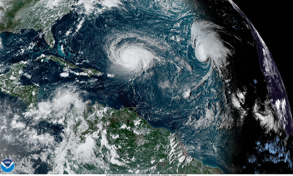
The looming loss of the high-tech microwave imaging is only the latest in a series of announced cuts by the Trump administration to hurricane research, including the loss of uncrewed vessels called Saildrones that capture data and Internet-popular video from the eye of the storm. A detailed budget request released Monday also calls for ending the majority of research conducted by the National Oceanic and Atmospheric Administration — including the Miami-based Atlantic Oceanographic and Meteorological Laboratory, home of the Hurricane Research Division.
Last week, in the latest controversial proposed cut, the Department of Defense announced it would abruptly stop sharing data from its Defense Meteorological Satellite Program, three weather satellites that are co-operated with NOAA due to “a significant cybersecurity risk.”
While Franklin said he has no explanation for what might suddenly concern the military on a system in use for decades, he and other meteorologists would like to see the service maintained through at least the end of hurricane season.
“How serious a cybersecurity threat can it be, then, if you can extend it a month? If you can extend it a month, can you extend it through the peak of hurricane season?” he asked.
NOAA did not immediately respond to a request for comment from the Herald, but an agency spokesperson downplayed concerns, telling Michael Lowry of Local10 that the missing satellite is “a single dataset in a robust suite of hurricane forecasting and modeling tools in the NWS portfolio.”
“NOAA’s data sources are fully capable of providing a complete suite of cutting-edge data and models that ensure the gold-standard weather forecasting the American people deserve,” the agency said.
‘Sunrise surprise’
Meteorologists say these satellites are irreplaceable. No other source of data or tool available gives the same look into the guts of a storm through the clouds at night.
The Special Sensor Microwave Imager Sounder, or SSMIS, allows forecasters to keep an eye on major changes to the rain bands surrounding the core of a storm during a dark and cloudy evening. That, Franklin said, gives forecasters clues as to whether a storm is about to get much stronger, much faster, a process known as rapid intensification.
Before that system — or without it — forecasters would get a “sunrise surprise,” he said. They would wake up to a much stronger or different storm than they saw the previous evening — and eight hours closer to making landfall.
“When you lose that, when these SSMIS data go away, and a forecaster is looking for clues that a storm is about to undergo this rapid strengthening process, it may be hours of delay before those clues are apparent from other types of data,” he said. “You might have known that six, ten hours earlier if you’d had one of these microwave passes.”
The satellite data also gives forecasters a chance to watch out for eyewall replacement cycles.
A strengthening storm will often form a new eye that envelops or overtakes the original one. In the middle of that process, a storm gets weaker but also grows wider, meaning the impacts spread along a much bigger area. When a storm goes through an eyewall cycle right next to land, like Hurricane Katrina did in 2005, it can have a significant impact on who gets hit and how hard.
Former hurricane hunter Andy Hazelton said the satellite also helped scientists about to fly into a storm see what they were up against and prepare for their mission.
“The microwave satellite is a key piece to look under the hood of a storm. It tells us what to expect,” said Hazelton, now an associate scientist with the University of Miami.
While hurricane hunter planes are “the best available tool” for peering inside a storm and seeing changes like these, planes aren’t sent out for every storm. So the microwave passes remain the best option for far-off storms, weaker storms or watching a storm in between plane flights, Franklin said.
And the loss of that data could be critical, especially for plotting the center of far-flung developing systems.
“Without the microwave imagery, I think some of these initial position estimates could easily be off by 50 or 60 miles or more in some cases,” he said. “The less well you know the initial state, the more the errors grow in time.”
Few possible replacements
In its statement, NOAA pointed to another satellite tool that also offers forecasters a view of storms — the Advanced Technology Microwave Sounder or ATMS. But hurricane scientists say it lacks the finer details of the military satellite getting taken offline.
“It’s like the graphics of a video game from the late ‘80s compared to the 2010s,” said Hazelton. “The resolution isn’t there.”
The satellites are not young, fresh tech. The first one in the program was launched in 1964, and NOAA didn’t assume shared responsibility over the technology until 1994. Franklin said he understands that at least one of the three is set to be phased out in September of next year. But there are no immediate plans for a replacement.
A new Department of Defense satellite with similar capabilities is set to launch in October, but Franklin said it isn’t clear if that data will be available for forecasters.
“The decision to just turn off the data processing when there’s still usable life left is somewhat inexplicable,” he said. “This is truly a self-inflicted wound.”
‘Hit after hit’
The loss of the crucial satellite comes weeks after NOAA ended its contract with Saildrone, a private company that provided several uncrewed drones that observed hurricanes from the air and sea and fed the data back to scientists.
“Unfortunately, due to the timelines associated with contracting, shipping, and transit, Saildrone is unable to support the Atlantic Hurricane mission this season,” the company said in a statement. “Our long-standing partnership of innovative collaboration with NOAA continues across many other mission opportunities.”
Hazelton, the hurricane researcher, said the information provided by Saildrone was “more experimental” than the satellite, but still helped inform and improve storm models.
“The more data, the better,” he said. “It kind of feels like one hit after another with losing these pieces of data.”
On Monday, NOAA released a more detailed budget request for the coming year for Congress to approve. While it doesn’t differ from the broad strokes of the budget released earlier this year, it offers even more detail on what cuts the agency could see under the new presidential administration.
The budget calls for cutting all NOAA research at climate labs and cooperative institutes across the country, including the Miami-based AOML lab and its academic partnership with the University of Miami.
Hazelton calls this a massive blow to what has, for decades, been a bipartisan mission: improving hurricane forecasting.
The administration said that crucial weather services would be re-organized under the National Weather Service, but it did not provide details.
“The proposal would basically get rid of all NOAA research,” he said. “Pretty much all of our research and development and modeling would be hit by this, even if on paper they’re moved to the National Weather Service.”
____
©2025 Miami Herald. Visit miamiherald.com. Distributed by Tribune Content Agency, LLC.


Comments