Colorado wildfires: Gov. Polis makes disaster declaration for five wildfires burning thousands of acres on western slope
Published in News & Features
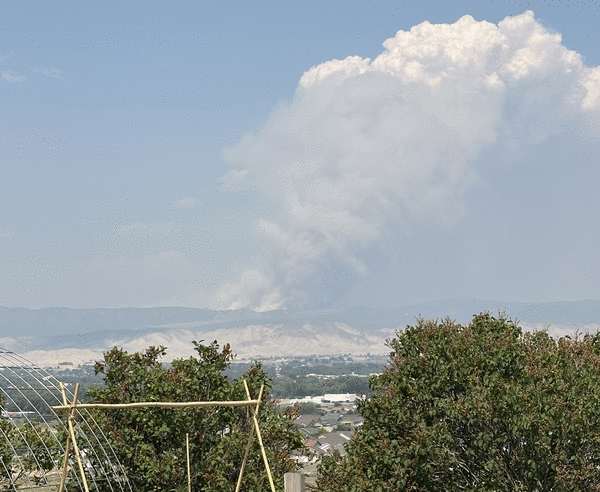
Five wildfires are burning on thousands of acres in western Colorado, including one that crossed into the state from Utah, fire officials said Sunday.
Colorado Gov. Jared Polis made a verbal “disaster declaration” Sunday afternoon for the fires currently spreading across Colorado’s western slope, according to a news release from his office.
The fires all stem from a Thursday lightning storm. They’re also burning in counties covered Sunday by Red Flag warnings for critical fire weather conditions and strong winds, according to the National Weather Service.
“Due to the dangerous fire conditions, the Colorado Department of Public Safety (CDPS) is engaged on the fires and will continue to be engaged and add resources to support local agencies as necessary,” the news release stated
State resources will be sent to the South Rim fire in Montrose County; the Sowbelly fire in Montrose, Delta and Mesa counties; the Turner Gulch and Wright fires in Mesa County; and the Deer Creek fire in Montrose County, according to the release.
South Rim fire in Montrose County
The lightning-sparked South Rim fire in Black Canyon of the Gunnison National Park has burned 3,556 acres with no containment since Thursday, according to a Sunday update from the National Park Service.
Bostwick Park in Montrose County and residences on M73, N73, N74 and O74 roads all remain under mandatory evacuation orders, according to fire officials.
The South Rim fire evacuation zone is bordered to the west by Lateral Ditch Road, the north by Black Canyon, the south by U.S. 50 and the east by East Portal, according to a map updated Saturday night by the National Park Service.
“Grab any important information, medications, and pets and leave the area immediately,” fire officials said. “Do not wait. Do not call 911 unless you have an emergency.”
Evacuated residents had all been safely relocated Sunday, according to the Montrose County Sheriff’s Office. Livestock evacuations are also ongoing.
Fire crews on Sunday were working to protect the dam and power infrastructure, private and National Park Service buildings and cultural sites on land belonging to the park service and the Bureau of Land Management, according to the morning update.
More than 190 fire personnel were fighting the flames on the ground or in the air, fire officials said.
Sowbelly fire in Montrose, Delta and Mesa counties
As of Sunday morning, the Sowbelly fire burning west of Montrose in the Dominguez Canyon Wilderness Area had charred 2,251 acres and was 0% contained, fire officials said.
The fire is burning forest land in both Delta and Mesa counties, officials said.
Crews in the field Sunday were working to secure a fire line along the rim of Escalante Canyon and scouting the wilderness area for holding features that could help stop the flames from spreading, according to the Bureau of Land Management.
The fire saw minimal growth overnight, but hot, dry and windy weather forecasted for western Colorado could spread the flames, fire officials said.
Another wave of dry lightning is also expected Sunday afternoon in the fire area, officials said.
Deer Creek fire in Utah, Montrose County
The Deer Creek fire, which has burned nearly 9,000 acres in eastern Utah, was rapidly approaching the Colorado border on Sunday, according to fire maps.
By 1:30 p.m. Sunday, state officials said that the Utah fire had reached Montrose County in western Colorado, according to Polis’s news release.
As of Sunday morning, the wildfire had grown to 8,925 acres with no containment, according to Utah Fire Info, a task force that partners with state and federal agencies.
The Utah wildfire sparked Thursday afternoon southeast of Moab and was on track to spread into Colorado on Sunday.
Federal officials said the cause of the fire is unknown.
“Yesterday, fire behavior increased dramatically on the northern side of the fire perimeter due to very strong, terrain-driven winds,” fire officials wrote Sunday morning on Facebook.
Strong winds on Saturday swept some of the flames up into a spinning column, according to fire officials. Multiple social media users called the event a “firenado.”
Wright Draw fire and Turner Gulch fire in Mesa County
Two lightning-sparked wildfires are burning on more than 1,000 acres of steep, rugged terrain near Gateway in Mesa County, according to the Upper Colorado River Interagency Fire Management Unit.
The Turner Gulch fire has spread to roughly 940 acres of Bureau of Land Management land, Operations Section Chief Tim Lavin said in a Sunday morning briefing. That’s nearly double the 512 acres it was burning on Saturday evening.
Lavin said hotshot crews are working on containment lines around the fire, but the mountainous area makes it dangerous for crews to work.
The evacuation zone stretches along four miles of Colorado 141 known as the “gravel pit” between mile markers 120 and 124, approximately 10 miles north of Gateway, Lavin said.
The area has been fully evacuated and crews are working to protect homes and structures from the fire, he said.
Multiple firefighting aircraft arrived yesterday, and more arrived Sunday, to help combat the flames from the air, Lavin said.
A size update was not available Sunday morning for the Wright Draw fire, which crews are still trying to find a way to access, Lavin said.
As of Saturday night, the fire had burned 160 acres, according to fire officials.
“The Wright Draw fire is sitting up on a very high, very steep terrain ledge,” Operations Section Chief Tim Lavin said. “That fire today has … crept down, and if it gets into this North Fork West Creek, it will make a significant run. So we’re trying to prepare for that.”
Neither of the wildfires had seen any containment Sunday.
_____
©2025 MediaNews Group, Inc. Visit at denverpost.com. Distributed by Tribune Content Agency, LLC.


Comments