Colorado wildfires: Western Slope fires scorch more than 31,000 acres
Published in News & Features
DENVER — Four fires burning on Colorado’s western slope have spread to more than 31,000 acres and forced ongoing evacuations, fire officials said Wednesday.
Disaster declarations have been issued for two of the wildfires actively burning with no containment: the Leroux fire burning near Hotchkiss in Delta County and the Elk fire burning near Meeker in Rio Blanco County.
Lightning sparked three of the fires over the weekend, and the flames rapidly grew in the Western Slope’s dry vegetation, exacerbated by windy, hot and dry weather, officials said. The cause of the fourth remains under investigation.
Multiple Colorado and federal recreation areas are closed Wednesday, including Oak Ridge, Rio Blanco, Colorow Mountain and Piceance state wildlife areas and parts of the White River National Forest and San Juan National Forest.
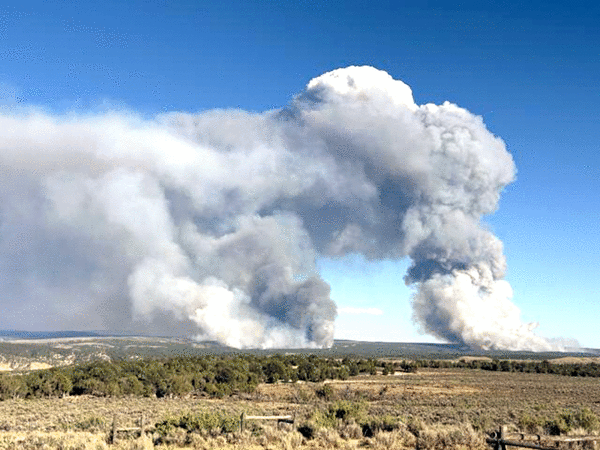
The Lee fire southwest of Meeker
A wildfire burning near Meeker in Rio Blanco County has scorched more than 22,000 acres, fire officials said Wednesday morning.
The Lee fire, which has since absorbed the Grease fire that also started nearby, was last mapped at 22,497 acres, fire officials said.
It’s nearly the size of the Turner Gulch fire, which is currently Colorado’s largest wildfire at 22,860 acres. That wildfire has been burning since early July in Mesa County.
Meeker is about 70 miles northwest of Glenwood Springs and 40 miles north of Interstate 70.
Afternoon winds fueled the fire, pushing the flames up to Colorado 13, fire officials said in a Wednesday morning update. The fire has not yet crossed the highway.
Firefighters are working to protect homes and other buildings on the east side of the fire, including along Colorado 13, according to the update. Crews on the fire’s western and southern edges are focused on securing fire lines and containing the flames.
Incident managers are “evaluating the direction and rates of fire spread” to determine if additional evacuations need to be issued.
As of Wednesday morning, the evacuation area was bordered to the east by Colorado 13 and the Grand Hogback, the north by Colorado 64, the west by Rio Blanco County Road 5 and the south by Bald Knob Mountain, Fourteenmile Creek and County Road 22, according to the evacuation map.
Multiple areas north and east of the current evacuation zones are on pre-evacuation status, according to the map.
The Elk fire east of Meeker
A second wildfire burning just miles away from the Lee fire, on the other side of Meeker, had consumed more than 8,300 acres as of Wednesday, according to fire officials.
The lightning-sparked Elk fire is burning on roughly 8,304 acres of land with no containment, fire officials said Wednesday morning. It has destroyed at least two homes and one outbuilding since it started Saturday afternoon.
More than 230 fire personnel are battling the Elk and Lee fires as of Wednesday morning, including seven aircraft, nine fire engines and seven hand crews, fire officials said.
Hot and dry conditions continue to fuel the fires on either side of Meeker, with red flag warnings scheduled from 11 a.m. to 8 p.m. Wednesday, Thursday and Friday, according to the National Weather Service.
The alert warns of low humidity between 8% and 13%, gusty winds up to 35 mph, and more.
“Fires will catch and spread quickly,” forecasters stated in the warning.
Fire officials said the weather is “conducive to large fire growth, with all key factors for extreme fire behavior.”
The area’s steep slopes, wind-exposed mesa and flammable vegetation also “promote rapid fire spread,” officials said. Several months of above-average temperatures, below-average precipitation and ongoing drought leading up to the fire have “severely stressed the ecosystem.”
Evacuations remain in place Wednesday.
The evacuation zone is bordered to the south by White River, the west by the Flat Tops Trail Scenic Byway, the north by County Road 14 and the east by Big Lick Reservoir, according to Rio Blanco County’s emergency map. Multiple other areas remain under pre-evacuation orders.
The Leroux fire in Delta County
Evacuations remain in place for the Leroux fire, which is burning just over a mile east of Redlands Mesa in Delta County with no containment.
The 179-acre fire had “reduced fire behavior” Tuesday compared to Monday, but crews have not reported any containment, according to Delta County emergency officials.
Smoke was reported near Oak Mesa outside of Hotchkiss, which is about 20 miles east of Delta, at about 2:30 p.m. Sunday. Evacuation orders were first issued early Monday morning as the fire began to rapidly grow, officials said.
As of Wednesday, the evacuated area included 3100 Road north of Oak Mesa Road, the 7X Ranch, residents along 3100 Road between the Leroux Creek bridge and the U.S. Forest Service Boundary and campers between Forest Service Road 128 and Bailey Reservoir.
The Stoner Mesa fire in Montezuma County
Part of the San Juan National Forest was evacuated Tuesday when a wildfire sparked amid the trees.
The Stoner Mesa fire was estimated to be roughly 250 to 300 acres Tuesday night. Fire officials are awaiting infrared mapping to determine its exact size, U.S. Forest Service officials said Wednesday morning.
Officials said the fire is burning about 20 miles northeast of Dolores, a town in Montezuma County about 45 miles northwest of Durango.
Dolores County officials issued evacuation orders for part of the San Juan National Forest on Stoner and Taylor Mesa. Evacuations include:
•Stoner Mesa Road, also known as Forest Service Road 686;
•Taylor Mesa Road, also known as Forest Service Road 545;
•All roads branching off the two Forest Service Roads;
•Mavreeso Campground;
•Burro Bridge Campground;
•And West Dolores Campground.
As of Tuesday evening, the wildfire was “still actively burning and demonstrating extreme fire behavior,” U.S. Forest Service officials said.
The cause of the fire is unknown, and no containment had been reported Wednesday.
An aerial video posted by the Forest Service shows a large column of smoke emerging from an area of dense trees. Flames are visible on the forest floor.
--------------
©2025 MediaNews Group, Inc. Visit at denverpost.com. Distributed by Tribune Content Agency, LLC.


Comments