Colorado wildfires: Crosho fire near Yampa doubles in size
Published in News & Features
DENVER — More evacuation orders rolled out across Colorado’s Western Slope on Wednesday as five active wildfires burn across hundreds of square miles.
Colorado’s largest wildfire reached the Garfield County line on Wednesday, prompting officials to scale up evacuation orders for people living northwest of Rifle.
New mandatory evacuation zones for the Lee fire include approximate boundaries of the Garfield and Rio Blanco county line to the north, Roan Cliffs Road to the east, Long Ridge to the south and Garfield County roads 401, 402 and 403 to the west.
Farther north, Routt County officials ordered mandatory evacuations as the Crosho fire doubled in size Wednesday, burning on 1,349 acres across the Rio Blanco County line and forcing evacuations east of Crosho Lake to Routt County Road 17.
Updated evacuation maps from the sheriff’s office s are available online.
The five active wildfires — the Lee, Elk, Oak, Stoner Mesa and Crosho fires — have charred more than 143,000 acres, or 222 square miles, on the Western Slope in recent days.
The Lee and Elk fires near Meeker
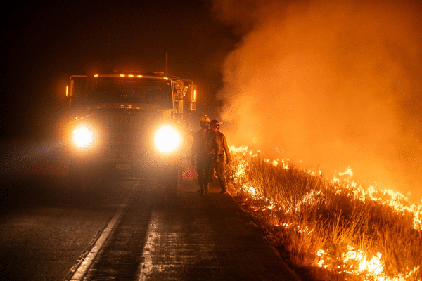
Hot, dry and windy weather is expected to create challenging conditions for firefighters battling Colorado’s largest active wildfire burning between Meeker and Rifle on the Western Slope.
Containment on the 120,650-acre Lee fire dropped to 4% as the wildfire pushed south into Garfield County for the first time on Wednesday afternoon, forcing new evacuations for people living near the Rio Blanco County line.
Firefighters are working on holding fire lines along Colorado 13 and establishing lines to the south by using roads, trails and other natural features, fire officials said in an update Wednesday.
It’s possible the wildfire could send up large plumes of smoke and create its own weather with pyrocumulus clouds.
Along with the smaller Elk fire, the two lightning-sparked wildfires burning on either side of Meeker have charred more than 135,000 acres as of Wednesday afternoon.
Containment on the Lee fire dropped from 7% to 6% on Monday after “fast-moving flames pushed by the wind” charred thousands of additional acres, according to fire officials. It dropped another 2% on Tuesday when the fire consumed nearly 4,000 additional acres.
Two fire weather watches are scheduled for western Colorado, including Rifle, from 11 a.m. to 10 p.m. on Thursday and Friday, according to the National Weather Service.
Dry thunderstorms forecast each day will be capable of producing frequent lightning and gusty winds, forecasters said in the alert. That, combined with "extremely dry conditions," could start new fires.
Ongoing evacuations include a stretch of Colorado 64 north of the fire, areas along Colorado 13 east of the fire from Colorado 64 to Monument Peak and multiple zones along the fire's southern edge.
Pre-evacuation orders are active for areas including near and along Big Beaver Creek, the Flat Tops Trail Scenic Byway, Red Canyon, Jordan Gulch, Colorado 64, Harris Gulch, the Grand Hogback, Ward Gulch and East Middle Fork Parachute Creek.
East of Meeker, the Elk fire is burning on 14,549 acres with 75% containment, fire officials said Wednesday. The wildfire has grown about 300 acres since Thursday.
As it winds down, resources and firefighters are being pulled off the Elk fire and shifted to the Lee fire.
The Oak fire, near Pagosa Springs
Evacuations lifted at noon on Wednesday for the 75-acre Oak fire burning near Pagosa Springs, according to the Archuleta County Sheriff's Office.
The fire sparked Sunday afternoon and evacuated two subdivisions. It also put a large section of Pagosa Springs on pre-evacuation status, sheriff's officials said.
Pre-evacuation orders were lifted Monday evening, but residents in the mandatory evacuation zone, including the Elk Park and Aspen Springs subdivisions, have not been able to return home.
Residents will need to provide an ID or proof of address at checkpoints to access the areas that had been under mandatory evacuation orders, sheriff's officials said.
The Oak fire was 47% contained as of Tuesday evening, sheriff's officials said.
The wildfire threatened more than 5,100 buildings and 2,000 homes, according to the Federal Emergency Management Agency.
Sheriff's officials said the wildfire damaged a small barn, one pump house, one pergola, one carport and a camper trailer, but no homes. The department has not updated the damage reported since Monday.
The Stoner Mesa fire, near Dolores
A wildfire burning in southwestern Colorado's San Juan National Forest consumed another 500 acres Tuesday night, fire officials said.
The Stoner Mesa fire, which started last week about 20 miles northeast of Dolores, was burning Tuesday morning on 6,618 acres, according to fire officials. By Wednesday morning, fire officials said it had charred 7,123 acres with no containment.
The fire had been mapped on Monday at 3,579 acres.
Shifting winds and drought conditions have contributed to the fire's growth, officials said at a Tuesday night community meeting in Rico.
The wildfire nearly doubled in size Monday, but the flames didn't spread as far during the day on Tuesday. Fire officials said the fire is finding less fuel to burn as it reaches Anchor Mountain, which stands between the fire and the town.
While most of the growth Tuesday was to the north along Stoner Mesa, flames are running into younger aspen stands that don't burn as easily, operations chief Brad Piertruska said in a Wednesday update.
Firefighters have finished inventorying homes and buildings in Rico and are now focused on building a contingency line to protect the town in the unlikely event the fire burns over Anchor Mountain. Rico remains on a pre-evacution status and parts of the national forest are closed to the public because of the fire.
Crosho fire near Yampa
A wildfire that sparked Monday in the Medicine Bow-Routt National Forests of Rio Blanco County, northeast of the Elk and Lee fires near Meeker doubled in size Wedensday, growing to 1,349 acres and forcing mandatory evacuations as it burned east into Routt County, fire officials said Wednesday.
People living east of Crosho Lake to Routt County Road 17 should leave immediately, county officials said. The evacuation zone includes stretches of County roads 13 and 15 and Heart Mountain. County fire crews are focused on protecting buildings that are threatened by the fire, officials said Wednesday.
Updated Routt County evacuation maps are available online.
The wildfire was discovered Monday at Crosho Lake, about 8 miles west of Yampa. The cause of the fire is unknown.
The fire was active overnight and throughout the day Wednesday as it spread into Routt County, U.S. Forest Service spokesperson Aaron Voos said. The fire is mainly burning in spruce and fir trees, which is causing spot fires that contribute to the spread.
Statewide impacts
The heaviest smoke will be in the areas closest to the fires, especially overnight and in the early morning, state health officials said.
Residents should consider limiting their time outdoors, especially young children, older adults and those with heart disease or respiratory illnesses, according to air quality advisories issued by the Colorado Department of Public Health and Environment.
The current advisories were issued Tuesday morning and are set to expire at 9 a.m. Wednesday.
If visibility drops to less than 5 miles, the smoke has reached unhealthy levels.
_____
©2025 MediaNews Group, Inc. Visit at denverpost.com. Distributed by Tribune Content Agency, LLC.


Comments