Hurricane Erin remains Category 3 as track shifts south; new system on Erin's tail
Published in News & Features
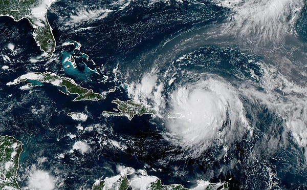
Hurricane Erin, after strengthening into a Category 5 storm early Saturday, weakened to Category 3 by Sunday morning and has taken a track slightly more south than originally forecast, the National Hurricane Center said. Meanwhile forecasters are tracking another possible system close on Erin’s heels that could develop near the Caribbean this week.
Despite recent wobbling, Hurricane Erin is still on a track to turn away from the U.S. East Coast over the next few days.
As of 11 a.m. Sunday, Erin was about 200 miles north-northwest of San Juan, Puerto Rico, with maximum sustained winds of 125 mph. It was moving west-northwest at 14 mph.
Erin’s forecast track will take it to the east of the Turks and Caicos Islands and the southeastern Bahamas, and it will be several hundred miles off the coast of North Carolina by late in the week.
Beachgoers along the U.S. coast from South Florida to Virginia are being warned of life-threatening rip currents this week as Erin passes to the east.
“While the threat of direct impacts in the Bahamas and along the east coast of the United States appears to be gradually decreasing, there will still be a significant risk of dangerous surf and rip currents along western Atlantic beaches next week,” the hurricane center said.
NOAA Hurricane Hunters found maximum sustained winds had increased to nearly 160 mph during a pass through the storm just after 11 a.m. Saturday morning, making it a Category 5 hurricane.
The storm joins last year’s Hurricane Milton as one of the fastest-intensifying Atlantic hurricanes. Like Erin, Milton also went from a Category 1 to a Category 5 storm in around 24 hours before making landfall as a Category 3 in Siesta Key in October.
Erin’s arrival earlier in the season makes it unique by comparison. The steep drop in the storm’s central pressure over the last 24 hours makes it the “fastest deepening Atlantic hurricane” before September, beating Hurricane Emily’s 2005 record, according to Sam Lillo, a meteorologist and software engineer for DTN Weather.
Most of Erin’s intensification occurred during a 12- to 15-hour window overnight, according to Dan Pydynowski, a meteorologist at AccuWeather. By 5 p.m. Friday, Erin’s winds had remained only 75 mph.
The hurricane “had all of the ingredients” necessary to rapidly intensify, Pydynowski said.
Erin has continued moving west into increasingly warm waters and it faces little to no wind shear, which tears apart storms. The dry air that hindered it earlier this week has moved away, and it’s far enough northeast of the Caribbean islands that there are no land masses interfering with its circulation.
Several islands along the northeast border of the Caribbean Sea remained under tropical storm watches.
Erin is expected to bring heavy rain up to 6 inches through Monday across Puerto Rico, and in the U.S. and British Virgin Islands and the southeastern Bahamas through Tuesday, the hurricane center said.
Elsewhere in the tropics
Hours after forecasters began tracking a new system in the western Atlantic Saturday, a westerly moving tropical wave arose off Africa.
Regarding the latter disturbance, the National Hurricane Center said, “An area of low pressure could form over the central tropical Atlantic during the middle to latter portion of next week from a westward moving tropical wave. Some subsequent development could occur as the system moves westward to west-northwestward at around 15 mph.”
It has a 20% chance of development over the next seven days.
Finally, an area of showers and thunderstorms off the coast of North Carolina could develop some over the next 24 hours, but conditions are expected to hinder any further development by Monday.
As of 8 a.m., Sunday it had a 10% chance of developing in the next two to seven days.
_____
©2025 South Florida Sun-Sentinel. Visit sun-sentinel.com. Distributed by Tribune Content Agency, LLC.


Comments