Tropical Storm Fernand forms in Atlantic while NHC tracks 2nd system
Published in News & Features
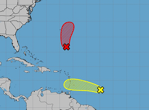
ORLANDO, Fla. — Tropical Storm Fernand formed Saturday afternoon in the central Atlantic but was expected to remain over the open ocean. It was the sixth named storm of the season.
According to NHC’s 5 p.m. advisory, Fernand was about 405 miles south-southeast of Bermuda with maximum sustained winds of 40 mph and higher gusts with northward movement at 15 mph. Tropical-storm-force winds extend outward up to 105 miles from the center.
“A north-northeastward motion at a gradually increasing forward speed is anticipated during the next couple of days, followed by a turn to the northeast,” forecasters said. “On the forecast track, Fernand should move well east of Bermuda and across the open waters of the subtropical North Atlantic.”
The forecast said some strengthening is expected during the next 48 hours and Fernand could be near hurricane strength Monday. Weakening is expected to begin Tuesday.
The other system tracked by the NHC was a tropical wave with disorganized showers and thunderstorms about 650 miles east of the Caribbean’s Windward Islands, as of the 2 p.m. advisory.
“Some development of this system could occur during the next few days while the system moves quickly westward at about 20 to 25 mph,” forecasters said. “Locally heavy rainfall and gusty winds are possible across portions of the Windward Islands as the system moves through on Sunday and Monday. By Tuesday conditions over the central Caribbean are expected to be unfavorable for further development.”
The NHC gave it a 20% chance to develop in the next two to seven days.
What had been the season’s first hurricane, Hurricane Erin, which had grown into a Category 5 storm with 160 mph winds last week, turned extratropical on Friday without making landfall, although it was blamed for nine deaths in the Cape Verde Islands. As of Saturday it no longer showed Erin on its outlook map.
It plowed across the Atlantic and turned to the north while dumping rain on the Leeward Islands, Virgin Islands, Puerto Rico, the Turks & Caicos, Bahamas and Outer Banks of North Carolina as it skirted the U.S. East Coast.
Swells from the storm continue to be a threat to the Atlantic coast Saturday.
The National Oceanic and Atmospheric Administration recently updated its season forecast to call for 13-18 named storms this year, of which five to nine would grow into hurricanes. Two to five of those would develop into major hurricanes of Category 3 strength or higher.
The height of hurricane season runs from mid-August into October while the entire six-month season runs June 1 to Nov. 30.
©2025 Orlando Sentinel. Visit orlandosentinel.com. Distributed by Tribune Content Agency, LLC.


Comments