Hurricane center gives high chance tropical depression will form this week
Published in News & Features
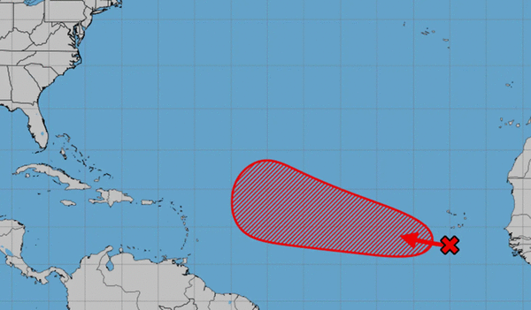
ORLANDO, Fla. – The National Hurricane Center on Tuesday forecast increasing offs a tropical wave in the far eastern Atlantic could develop into the season’s next tropical depression or storm.
As of the NHC’s 8 a.m. tropical outlook, the system was located south of the Cape Verde Islands with disorganized showers and thunderstorms.
“Environmental conditions appear conducive for gradual development of this system during the next several days, and a tropical depression is likely to form later this week or this weekend,” forecasters said. “This system is expected to move westward to west-northwestward at around 15 mph across the eastern and central tropical Atlantic through the weekend.”
The NHC gave it a 20% chance to develop in the next two days and 70% chance to develop in the next seven.
It’s too early to say if the system will have any impact on Florida.
If it develops, it would be the seventh tropical cyclone of the season and could become Tropical Storm Gabrielle.
The most recent, Tropical Storm Fernand, became post-tropical last week in the north Atlantic.
Only one of the six named storms has reached hurricane status. What had been Hurricane Erin, which grew to Category 5 major hurricane status with 160 mph winds, ended up not making landfall, but did prompt warnings in the Caribbean and U.S. Atlantic coast earlier this month.
The National Oceanic and Atmospheric Administration in early August updated its season forecast to call for 13-18 named storms this year, of which five to nine would grow into hurricanes. Two to five of those would develop into major hurricanes of Category 3 or higher.
The height of hurricane season runs from mid-August into October while the entire six-month season runs June 1 to Nov. 30.
-------------
©2025 Orlando Sentinel. Visit at orlandosentinel.com. Distributed by Tribune Content Agency, LLC.


Comments