Hurricane center ups odds for new Atlantic system as Tropical Storm Gabrielle churns
Published in News & Features
The National Hurricane Center on Sunday increased the odds that a tropical wave moving across the Atlantic could become the season’s next tropical depression or storm while Tropical Storm Gabrielle looked to intensify into the season’s second hurricane.
Gabrielle is expected to move well clear of Bermuda in the open Atlantic, but where the new system could threaten remains in question.
As of the NHC’s 8 a.m. tropical outlook, the broad tropical wave was in the central tropical Atlantic west-southwest of the Cape Verde Islands.
“Although environmental conditions are not favorable for initial development of this system over the next day or two, these conditions should gradually become more favorable for development by the middle to latter part of this week, and a tropical depression could form while the system moves west-northwestward to northwestward across the central Atlantic,” forecasters said.
The NHC increased the odds to 40% it could develop in the next seven days.
If it were to become a named storm, it could become Tropical Storm Humberto.
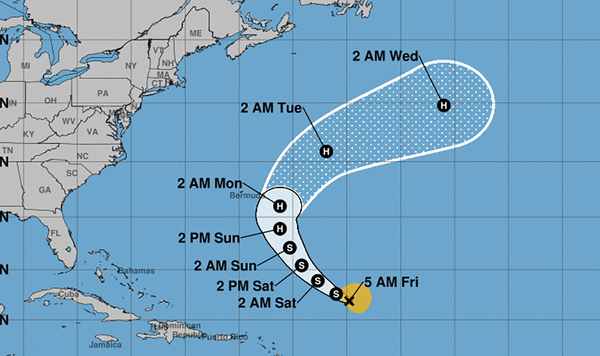
As for Tropical Storm Gabrielle, as of the NHC’s 11 a.m. advisory, the storm had 65 mph sustained winds located about 390 miles southeast of Bermuda, headed northwest at 12 mph.
Tropical-storm-force winds extend out 140 miles from its center.
“A turn toward the north is forecast on Monday, followed by a faster northeastward or east-northeastward motion on Tuesday. On the forecast track, the center of Gabrielle is expected to pass east of Bermuda on Monday,” forecasters said.
Projections have it growing into a Category 1 hurricane by Sunday evening, which would make it only the second hurricane of the season. It’s expected to intensify further into a Category 2 hurricane by Monday topping out with 100 mph winds, although shifting back east into the open Atlantic after passing near Bermuda.
The NHC warned swells from the system continue to threaten Bermuda with potential life-threatening surf and rip conditions. The swells will reach the U.S. East Coast from North Carolina northward and into Canada starting Sunday and continuing through early this week.
The climatological peak of the Atlantic hurricane season was on Sept. 10, but 60% of annual activity has historically happened after this date, the NHC stated.
The only hurricane has been Hurricane Erin, which grew into a massive Category 5 system with 160 mph winds but remained in the Atlantic without making landfall.
The National Oceanic and Atmospheric Administration in early August updated its season forecast to call for 13-18 named storms this year, of which five to nine would grow into hurricanes. Two to five of those would develop into major hurricanes of Category 3 or higher.
Hurricane season runs from June 1 to Nov. 30.
_____
©2025 Orlando Sentinel. Visit orlandosentinel.com. Distributed by Tribune Content Agency, LLC.


Comments