Jamaica could feel hurricane strength wind from slow-moving Melissa by Sunday
Published in News & Features
Tropical Storm Melissa continues to linger over the central Caribbean, moving slowly while unleashing torrential rain across Haiti, the Dominican Republic and Jamaica. The storm already has claimed at least three lives and destroyed a bridge in Haiti, and is expected to strengthen into a major hurricane by Sunday, according to forecasters.
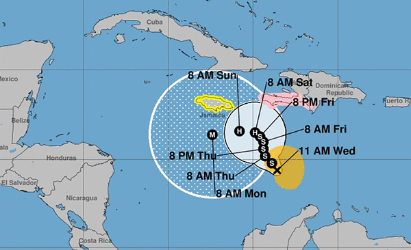
Tropical storm–force winds are expected to reach Jamaica on Saturday night, with hurricane-strength winds likely by Sunday or Monday, according to the National Hurricane Center’s 11 a.m. Saturday update. The storm is moving slowly toward the west-northwest at about 1 mph with maximum sustained winds at around 70 mph.
The storm sits 155 miles from Kingston, Jamaica, and 235 miles from Port-Au-Prince, Haiti, as of Saturday morning.
When will Melissa make landfall?
The storm is expected to make landfall in Jamaica in about 60 to 72 hours as an upper-end Category 4 hurricane, NHC forecasters say. This is possibly the strongest storm ever to make direct landfall there since tropical cyclone records keeping began in the Atlantic Basin.
Melissa is expected to bring 15 to 25 inches of rain to parts of southern Hispaniola and Jamaica through Tuesday, with some areas in Haiti’s Tiburon Peninsula possibly seeing up to 35 inches. More heavy rain is likely after Tuesday, though it’s too early to know exactly how much.
“Potential catastrophic flash flooding and landslides are possible across portions of Jamaica and the southern Dominican Republic, while catastrophic flash flooding is anticipated in southern Haiti,” forecasters wrote in the 11 a.m. update. Peak storm surge heights could reach 7 to 11 feet above ground level in Jamaica, forecasters say.
In eastern Cuba, 5 to 10 inches of rain are expected through Tuesday, with some spots possibly getting up to 12 inches. More heavy rain and storm surge is also possible later in the week.
Haiti, Jamaica and Dominican Republic already feel the effects
The storm has already killed at least three people in Haiti this week during landslides attributed to the heavy storms. Haiti’s Office of Civil Protection said flooding of the Saint Martin River caused by heavy rains also destroyed a bridge in Saint Suzanne in the northeast region of Haiti.
Across Hispaniola, the island shared by Haiti and the Dominican Republic, residents are already seeing overnight flooding, downed trees and landslides in some areas. Given Melissa’s heavy rainfall, both countries are at an increased risk of experiencing catastrophic disasters even without a direct hit. Residents of Kingston, Jamaica, were already dealing with floodwaters on Friday, as concerns are growing that the impact could be the worst since Hurricane Gilbert devastated the island in 1988. Parts of Jamaica are still recovering from last year’s Hurricane Beryl, which made landfall as a Category 4 storm.
In anticipation, a team of linesmen from the United States, Canada and St. Vincent arrived in the country this week to help restore power if needed. Also countries such as The Bahamas have deployed flights to evacuate their students studying in Jamaica. Jamaica’s director of emergency management, Richard Thompson, said the island has 881 shelters prepared for residents to seek refuge.
The island is under a tropical storm warning and hurricane.
Where is Melissa headed? Will it affect Florida?
Melissa’s movement had been slowed down by a pocket of wind shear that helped to balance out the storm-fueling effects of the warmer-than-average waters it is crossing.
But forecasters say the storm has started to recover from the shear and is becoming better structured. Because it’s moving slowly over very warm waters — the warmest in the Atlantic — conditions are ideal for rapid strengthening.
By early next week, Melissa is projected to strengthen into a powerful Category 4 hurricane. Forecasters expect it to reach near-peak intensity as it makes landfall and moves across Jamaica on Monday and Tuesday. However, the exact path of the storm’s center remains uncertain.
The hurricane center’s official forecast extends only through Wednesday, but long-range computer models — often referred to as spaghetti models — continue to indicate that Melissa will curve northeastward after leaving Cuba and avoid Florida. NHC forecasters say that a trough in the southeastern U.S. will weaken Melissa and push it northeast.
_____
©2025 Miami Herald. Visit miamiherald.com. Distributed by Tribune Content Agency, LLC.


Comments