Winter storm moves out of Central KY, but dangerously cold temps are in forecast
Published in News & Features
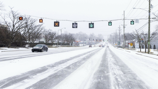
LEXINGTON, Ky. — City crews are facing bitterly cold temperatures Monday as they dig Lexington out of Winter Storm Fern’s aftermath.
Lexington received 5.5 inches of snow and 1.48 inches of precipitation from the snowstorm Saturday and Sunday, according to the National Weather Service. Gov. Andy Beshear said the state received less snow but more ice than expected, making recovery from the snowstorm more dangerous.
Allen, Barren, Monroe and Pulaski counties were hit the hardest, Beshear said.
A winter storm warning is still in effect until noon, Monday, Jan. 26 as travel remains difficult, and some areas could get blowing snow from high winds.
The city is also under a cold weather advisory until 7 p.m., according to the NWS. The projected high temperature in Lexington Monday is 12 degrees and the low is 2 below, but wind chill temperatures will dip well into the negatives.
Following the cold weather advisory, an extreme cold warning will be in effect from 7 p.m. Monday to 11 a.m. Tuesday, Jan. 27. The NWS said dangerously cold wind chill temperatures as low as negative 20 degrees could result in hypothermia or frostbite.
The temperature will not rise above freezing this week and most of the weekend, the agency said. The snow and ice from the winter storm is not expected to start melting, and prolonged effects from the snowstorm are expected.
City officials are still urging people to avoid non-essential travel. Road crews are working on keeping major routes, such as Main Street, Harrodsburg Road and Newtown Pike, passable while clearing other streets.
Most major routes are also snow emergency routes. The city said parking on those routes is banned while a state of emergency is in place.
Beshear said more than 1,000 Kentucky Transportation Cabinet trucks are on the road clearing roads Monday. More than 300 contractors are also assisting.
While officials are hoping for a window of warmer temperatures Monday or Tuesday to make significant progress on clearing the roads, Tuesday morning’s commute is expected to be slick.
“It’s a heavy lift because it hit the entire state,” Beshear said. “We’re throwing everything we have at it to try to get you all mobile in the next couple of days.”
Between midnight and 6:30 a.m. Monday, the Lexington Police Department responded to one non-injury collision, 19 reports of a motorist needing assistance, six traffic hazards and five escorts. Drivers can check the status of the roads on the city’s snow and ice updates webpage and the city’s live traffic cameras to get real-time views of the road conditions.
All city offices not involved in winter weather response are closed Monday, according to Lexington Emergency Management. Trash collection is also canceled Monday, and Mayor Linda Gorton postponed her annual state of the city speech to Thursday, Jan. 29.
Fayette County Public Schools and the University of Kentucky canceled in-person classes for all students Monday. The Kentucky General Assembly will not convene as scheduled for its legislative session that day.
The city’s emergency operations center will remain open until Tuesday morning, and the emergency winter weather plan will remain in effect until Tuesday, Feb. 3.
©2026 Lexington Herald-Leader. Visit at kentucky.com. Distributed by Tribune Content Agency, LLC.


Comments