After Philly's biggest snow in 10 years, a very big chill is coming
Published in News & Features
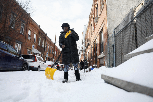
PHILADELPHIA — For the Philly region Monday it wasn’t so much a matter of digging out from the heftiest snowfall in a decade, it was more like a chipping, shaving, scraping, expletive-inducing, and ice-chunk hurling operation.
Public transportation appeared to be getting back on track, and major roads were open for business with speed reductions removed, thanks to crews working through the weekend.
But expect some side streets in the city and elsewhere to remain fit for sleigh rides this week and trash pickup to be delayed. City offices will be shut down again Tuesday, as will Philly school buildings, with Camden and more calling for a snow day or opting for remote learning.
And if you’re stepping outside, get used to that underfoot crunching sensation. The removal operation isn’t going to get much help this week from the atmosphere. It’s about to turn about as frigid as it ever gets around here. New Jersey officials are warning of “historic” demands on energy.
“We’re going to be in the freezer all week,” said Mike Gorse, meteorologist at the National Weather Service Office in Mount Holly. Philly may have its first zero-degree reading in 32 years later in the week.
It’s as if after recent wimpy winters, the Arctic is reacquainting with Philly and much of the rest of the East.
And did we mention another snow threat for the weekend?
“There’s a chance,” said Marc Chenard, meteorologist with NOAA’s Weather Prediction Center in iced-over College Park, Md., who was among those who had to chuck some frozen boulders before leaving for work Monday morning. “I had to chip it and carry it in pieces,” he said. Sound familiar?
Why this storm was particularly challenging
Snow totals for the biggest snowfall since Jan. 22-23, 2016, varied throughout the region; the inconveniences, not so much.
A general 8 to 12 inches of snow and sleet accumulated while temperatures remained mostly in the teens Sunday, 10 degrees or more below forecast.
A shallow layer of warmer air caused a changeover to sleet, and the tiny ice balls remained frozen for the entire trip through the stubbornly cold air near the surface. As much as 2 to 3 inches of sleet piled on, containing the same amount of liquid as several inches of snow.
That added weight to the snowpack. Based on the amount of melted precipitation measured in the 9.3 inches at Philadelphia International Airport, the snowpack weighed about as much as a 12- to 15-inch pile of the pure flaky fluff.
On a 200-square-foot driveway — a 10 by 20 — what fell Sunday weighed about 1,100 pounds. On a 100-square-foot sidewalk — 5 by 20 — that would be about 550 pounds.
In addition, ice tends to be rather shovel resistant.
This is going to be a memorably cold week in Philly
The ice and snow isn’t going to give up easily. On Monday, temperatures topped out in the upper 20s, and that’s going to be warmest day of the week.
Based on the forecast, it may not get above 28 degrees until next week, said Chenard, a cold streak the region hasn’t seen in decades.
Chenard said the upper-air patterns remain in place to import Arctic air on winds from the northwest for at least the next several days.
In fact, temperatures may have trouble getting out of the teens in Philly until the weekend, and Philly has a shot at reaching zero for the first time in 32 years.
The forecast lows are in the single digits all week, and down to 1 degree on Friday morning and 2 degrees on Saturday, the National Weather Service says. Both would be record lows for the dates.
The stubborn snow cover “absolutely” will increase the chances of the airport reaching zero for the first time since January 1994, Gorse said. Snow is ideal for radiating daytime warmth (such as it is) into space.
Temperatures will moderate some on the weekend, he said, but that might come in advance of yet another storm.
Said Chenard, “There will be coastal low. It’s a matter of how close it is.”
One historic footnote in the Philly weather annals
Philly’s official snowfall total for the winter stands at 15.7 inches, almost double normal for the date and double what fell all of last season.
Sunday’s was not only the biggest snow in 10 years, it also set a record for a Jan. 25.
It beat the 8.5 inches of Jan. 25, 2000, a day that the weather service just as soon would like to forget.
The storm came as a surprise, just a week after a weather service honcho announced a computer upgrade that would bring the nation closer to a “no surprise” era.
Expect surprises to continue.
_____
Staff writers Ximena Conde, Kristen A. Graham, Maddie Hanna, Rob Tornoe, and Nick Vadala contributed to this article.
_____
©2026 The Philadelphia Inquirer. Visit inquirer.com. Distributed by Tribune Content Agency, LLC.


Comments