Nor'easter lashes New York City with rain, intense winds
Published in News & Features
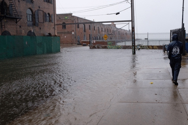
NEW YORK — The powerful early-season nor’easter that pounded the East Coast Saturday downed trees and flooded New York City streets and roadways as it unleashed heavy rain and powerful winds across the five boroughs.
The worst of the storm, though, was expected Saturday evening starting around 8 p.m. as a state of emergency was declared for New York City, New Jersey and Long Island through the weekend.
By the afternoon, around 0.6 inches of rain had been recorded in Central Park, about equal to an average rainy day. No weather-related deaths linked to the weather had been reported in the city.
Impacts to air travel were minimal during the early part of Saturday, though delays and disruptions were expected to ramp up as conditions deteriorate.
Travelers flying in and out of the Boston Logan International Airport have been the most affected, with about a quarter of its flights — around 130 departures — canceled, according to FlightAware.
Most outdoor events in the city were canceled as the rain fell — including the 100th Annual San Gennaro Festival procession march through Little Italy, which was scheduled for Saturday afternoon.
The Tunnel To Towers 5K Run and Walk on Sunday was still going on as scheduled, even though runners were warned that parts of the Hugh Carey Tunnel might have standing water inside.
Gov. Kathy Hochul said Saturday that the city was prepared for the storm, telling reporters that state agencies are taking an “all hands-on-deck approach” to best manage the severe weather.
“The rain is underway, and while it’s only a half an inch or so thus far, mark my words: Much more is coming,” she warned, adding that coastal flooding remains the biggest concern.
“We expect waves as tall as 20 feet in some areas,” the governor said. “That is a strong storm. It’s ferocious and needs to be taken seriously. It’s going to intensify over the next day.”
Hochul warned New Yorkers against heading to the coast or going into the water as the storm raged.
“Conditions are extremely dangerous. Anyone who goes in or near the water this weekend are literally gambling with their lives,” she said. “Don’t tempt Mother Nature. Don’t risk your life.”
The initial brunt of the storm hit late Saturday morning, with rainfall totals clocking in at around half an inch so far, NYC Emergency Management said later on Saturday. Gusts reached 45 mph citywide and up to 55 mph at Kennedy Airport, the agency noted.
Streets and highways in low-lying areas by the coast were already flooded as the storm persisted. In Howard Beach, streets were flooded. A handful of people were seen kayaking toward the local train station.
Drivers of at least two vehicles left disabled by the floodwaters were forced to abandon their rides near Christie Avenue and Junction Boulevard in Elmhurst, Queens, according to reports.
Suki Kang, a visiting nurse practitioner, had to have her car towed after she became stuck in the rising waters in the Rockaways.
Before her car conked out in the rising water, she had watched another vehicle make it down the flooded street. Her car wasn’t quite as lucky.
“I thought it would be OK,” she said. “Now, the water is coming up and it’s stuck. So I had to call 911. I was so scared.”
Since Friday, the city Parks Department has received about 640 requests for downed or damaged trees, mostly in Queens and Brooklyn, the city’s Office of Emergency Management said.
Around 6 a.m. on the Jackie Robinson Parkway, two cops were hospitalized with minor injuries when their marked cruiser was rear-ended by a Toyota Sonata. The cops were securing a downed tree that was blocking the highway when the Sonata crashed into them, cops said.
Commissioner Marie Therese Dominguez of the state Department of Transportation said there were 67 vehicle collisions on Long Island roads on Friday night caused by the storm.
As the weather system pushes closer to the city, “bands of moderate to heavy rain” will continue “to move in from the east,” the National Weather Service warned. “Some embedded convection with thunderstorms and lightning strikes have occurred.”
Starting around 8 p.m., “the heaviest rain arrives in bands falling at up to 1 inch per hour,” the agency said. The rain will continue through Sunday morning.
“Tonight through late Sunday morning is the worst time to travel,” NYC Emergency Management warned. “City crews are clearing downed trees, responding to flooding, and keeping rescue teams staged along the coast.”
Rainfall projections for New York City and Long Island are between 4 and 6 inches, up from initial projections, which means there is an increased likelihood of flash flooding in those areas, as well as in southeastern Connecticut.
In Queens and Long Island, coastal flooding could reach up to 3 feet, with winds of up to 60 mph expected. The gusts will likely be strong enough to down trees and power lines, meteorologists warned.
Reports of power outages were already coming in early Saturday morning, particularly across Nassau and Suffolk counties on Long Island, according to the NWS.
As of midafternoon, nearly 800 New York City residents were in the dark, the majority of them in Queens, while in Nassau and Suffolk counties, 2,600 and nearly 9,000 people, respectively, were without electricity, per Poweroutage.us.
The storm is also expected to trigger travel disruptions, including road closures anticipated along the waterfront. City officials have warned to avoid travel when possible this weekend.
The nor’easter is forecast to linger over the area, with rain expected to continue from Saturday into Sunday, according to the Weather Channel.
On Monday, it will start to weaken and move out of the area, with some showers expected throughout the day before the sun returns on Tuesday and Wednesday.
©2026 New York Daily News. Visit nydailynews.com. Distributed by Tribune Content Agency, LLC.





Comments