Florida's Gulf Coast could see impacts from the next named storm of the season
Published in News & Features
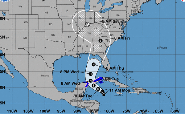
ORLANDO, Fla. — A disturbance in the Caribbean is set to strengthen into the next named storm of the season soon, and its future track could take it toward Florida by the middle of the week.
Monday morning, the National Hurricane Center said the system was on the cusp of forming a tropical depression or tropical storm, with an 80% chance of developing in the next 48 hours.
Forecasters warned that storm watches and warnings could be required for the Yucatan Peninsula and western Cuba as soon as Monday mid-morning. After that, the system — potentially Tropical Storm Helene — computer models show a potential track into the Gulf of Mexico then possible toward Florida’s Gulf Coast or Panhandle.
South Florida could see rain, potentially heavy, beginning as soon as Wednesday and lasting into the weekend.
If Helene does form, its path forward is lined with some of the warmest waters in the Atlantic basin. The waters in the northeast Gulf are about 2 degrees Celsius warmer than average, posted Ben Noll, a meteorologist with New Zealand’s National Institute of Water & Atmospheric Research, on Twitter.
“It’s concerning from a potential intensity and moisture availability perspective!” he wrote.
©2024 Miami Herald. Visit at miamiherald.com. Distributed by Tribune Content Agency, LLC.


Comments