Hurricane Imelda bears down on Bermuda, but Florida coastal dangers remain
Published in News & Features
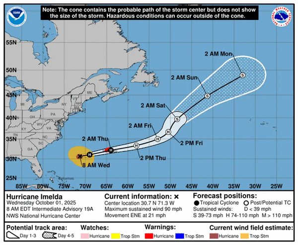
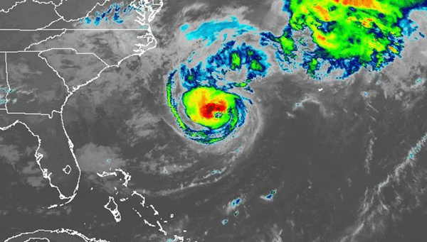

ORLANDO, Fla. — Hurricane Imelda on Wednesday took aim at Bermuda forecast to pass by the island close to Category 2 strength, according to the National Hurricane Center.
As of the NHC’s 8 a.m. advisory, Imelda had 90 mph sustained winds, making it a strong Category 1. It was located about 395 miles west-southwest of Bermuda moving east-northeast at 21 mph.
Hurricane-force winds extend out 60 miles and tropical-storm-force winds extend out 230 miles from its center.
“On the forecast track, the core of the hurricane will be near Bermuda this afternoon or evening and move away from the island by Thursday afternoon,” forecasters said. “Imelda is then expected to become an extratropical low in a couple of days, with gradual weakening thereafter.”
Bermuda remained under a hurricane warning with hurricane conditions expected by Wednesday evening and tropical-storm conditions by Wednesday afternoon.
Forecasters expect 2-4 inches of rainfall into Thursday that could lead to flash flooding while coastal flooding from storm surge and onshore winds creating large, damaging waves is also expected.
The swells from Imelda and Hurricane Humberto continue to move across the Atlantic back to the U.S. East Coast and Bahamas that can cause life-threatening surf and rip current conditions.
The National Weather Service in Melbourne said waves of 6-9 feet could be expected north of Cape Canaveral and waves of 5-8 feet south of the cape that during high tide Wednesday from 1-4 p.m. could lead to continued beach erosion.
A high surf advisory as well as a high risk of rip currents is in place at all Central Florida beaches for the foreseeable future, the NWS stated.
“At the beaches, hazardous conditions in the surf are forecast to continue through at least Saturday as onshore winds persist through an extended period and long period swells from distant Hurricane Humberto arrive to the local waters,” the NWS stated in its forecaster’s discussion. ” Breaking waves of 5 to 8 feet will continue to be possible alongside a high risk of rip currents. Entering the surf will continue to be strongly discouraged.”
Boating conditions continue to be hazardous off Florida’s east coast as well with forecast 7- to 9-foot waves nearshore and 12 feet offshore waves near the Gulf Stream.
Hurricane Humberto on Wednesday moved farther away from any land and was expected to become extratropical by Thursday.
As of NHC’s 5 a.m. advisory, Humberto had maximum sustained winds that had dropped to 80 mph, making it Category 1. It was located about 295 miles west-northwest of Bermuda moving northeast at 14 mph.
Hurricane-force winds extend out 40 miles and tropical-storm-force winds extend out 265 miles.
“A faster motion toward the east-northeast is expected today until the system merges with a developing frontal boundary tonight,” forecasters said. “Slight weakening is possible today, but Humberto is expected to remain a powerful cyclone until it merges with a frontal boundary tonight.”
So far the 2025 season has had nine named cyclones, all of which have grown to tropical-storm strength. Four have now become hurricanes, with all but Imelda having grown into major hurricanes.
The National Oceanic and Atmospheric Administration in early August updated its season forecast to call for 13-18 named storms, of which five to nine would grow into hurricanes. Two to five of those would develop into major hurricanes of Category 3 or higher.
The U.S. has had just one landfall so far this season when Tropical Storm Chantal moved ashore in July in South Carolina. It’s the first time in 10 years the U.S. has avoided a hurricane landfall by the end of September.
Hurricane season runs from June 1 to Nov. 30.
-------------
©2025 Orlando Sentinel. Visit at orlandosentinel.com. Distributed by Tribune Content Agency, LLC.


Comments