Tropical Storm Lorenzo still churning in Atlantic
Published in News & Features
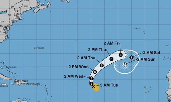
ORLANDO, Fla. — The National Hurricane Center on Tuesday continued to track Tropical Storm Lorenzo, although it remained no threat to land.
As of the National Hurricane Center’s 5 a.m. advisory, Lorenzo had 60 mph sustained winds located about 1,330 miles west of the Cape Verde Islands moving northwest at 15 mph.
“This motion is expected to continue today, followed by a turn to the north tonight. A northeastward motion is expected on Wednesday and Thursday,” forecasters said. “Little change in strength is forecast over the next few days.”
Tropical-storm-force winds extend out up to 175 miles from the center.
Of the 12 named storms this year, four have grown into hurricanes, and three of those became major hurricanes.
Only one of those, Tropical Storm Chantal, made a U.S. landfall this year.
Tropical Storm Jerry fizzled out most recently after sideswiping the Caribbean’s Leeward Islands late last week, but its kicked-up surf began hitting the Florida coast Sunday, that mixed with King Tides and a powerful nor’easter to make dangerous conditions.
“There is a high risk of life-threatening rip currents at all beaches. Entering the surf is not advised!” warned the National Weather Service in Melbourne again on Tuesday.
Poor to hazardous boating conditions are also forecast offshore with 4- to 6-foot seas, the NWS stated.
Hurricane season runs from June 1-Nov. 30.
-------------
©2025 Orlando Sentinel. Visit at orlandosentinel.com. Distributed by Tribune Content Agency, LLC.


Comments