Hurricane center keeps eyes on tropical system that could target Florida while Tropical Storm Barry strikes Mexico
Published in Weather News
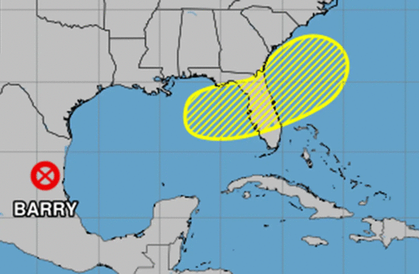
Tropical Storm Barry disintegrated after striking Mexico early Monday morning while the National Hurricane Center continued to forecast the season’s next tropical depression or storm could form off the coast of Florida later this week.
In its 8 a.m. tropical outlook, the NHC said an area of low pressure could develop off either the southeast U.S. coast, over Florida or over the eastern Gulf as a frontal boundary is forecast to stall and weaken coming from the north. Its bubble of potential development sweeps across all of Central Florida.
“Some gradual tropical or subtropical development could occur thereafter as the low moves little,” forecasters said.
The NHC gave it a 20% chance for development in the next seven days.
The National Weather Service in Melbourne said to expect a high chance of rain no matter what forms around the Fourth of July and into that weekend.
“Unsettled conditions with high rain chances expected to continue into the extended forecast range as the stalled front accompanied by copious moisture sags into the southeast and towards Florida,” forecasters said. “Heavy rainfall will be the primary concern regardless of development. Multiple rounds of showers and storms will be possible each day, increasing/compounding concerns for flooding.”
If it were to develop into a named storm, it could become Tropical Storm Chantal, the third named storm of the Atlantic hurricane season.
The second only formed Sunday morning in the Bay of Campeche off of the Mexican coast, but lasted less than a day.
Tropical Storm Barry made landfall after midnight Monday having grown some in strength with sustained winds of 45 mph.
By 5 a.m., though, the remnants of Barry were located about 100 miles northwest of Tampico, Mexico with winds of 30 mph as it moved northwest at 12 mph.
The system was still expected to drop 3-5 inches of rain with some areas getting as much as 10 inches across portions of the Mexican states of San Luis Potosi and Tamaulipas through today.
“This rainfall may produce life-threatening flooding and mudslides, especially in areas of steep terrain,” the NHC stated.
The slow start of the 2025 Atlantic hurricane season did not see the first named storm form — Tropical Storm Andrea — last week, out in the middle the Atlantic where it spun for less than a day with no threat to land.
The National Oceanic and Atmospheric Administration, though, still forecasts 13 to 19 named storms this year, of which 6-10 will become hurricanes. Three to five of those would grow into major hurricanes of Category 3 strength or higher.
Hurricane season runs through Nov. 30.
-----------
©2025 Orlando Sentinel. Visit at orlandosentinel.com. Distributed by Tribune Content Agency, LLC.


Comments