Hurricane Erin forms, forecast to become major Cat 3 storm as it skirts Caribbean, NHC says
Published in Weather News
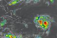
ORLANDO, Fla. — Hurricane Erin became the first hurricane of the season Friday morning, and is expected to develop into a major Category 3 storm this weekend as it passes to the north of Puerto Rico in the Atlantic, according to the National Hurricane Center.
As of the NHC’s 11 a.m. advisory, the center of Erin was located about 460 miles east of the northern Leeward Islands moving west-northwest at 18 mph with maximum sustained winds of 75 mph, making it a Category 1 hurricane.
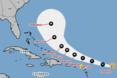
“This motion is expected to continue into the weekend. On the forecast track, the center of Erin is likely to move near or just north of the northern Leeward Islands over the weekend,” said NHC senior hurricane specialist Jack Beven. “Steady to rapid strengthening isexpected during the next two to three days, and Erin is forecast to become a major hurricane during the weekend.”
Hurricane-force winds extend out 25 miles and tropical-storm-force winds extend out 115 miles as it became more organized.
A tropical storm watch is in place for Anguilla and Barbuda, St. Martin and St. Barthelemy, Saba and St. Eustatius, and Sint Maarten.
The system is expected to drop heavy rains late Friday and into the weekend with up to 6 inches in some parts across the northernmost Leeward Islands, the U.S. and British Virgin Islands as well as southern and eastern Puerto Rico. Flash flooding, landslides and mudslides are a threat.
The system passed by the Cape Verde Islands earlier in the week, causing flash floods that were blamed for at least nine deaths. It has been moving quickly across the Atlantic.
The swells from the storm with dangerous surf and rip currents will begin hitting the northwestern Caribbean islands today, and spread to the Bahamas, Florida and rest of the U.S. East Coast as the storm intensifies and moves up into the Atlantic.
“The global and regional hurricane models are in good agreement that Erin will become a powerful and increasingly large hurricane over the southwestern Atlantic over the weekend and into next week,” Beven said.
The storm is moving into warmer Atlantic waters and wind shear is forecast to diminish.
“Erin is currently in a favorable environment for strengthening, although there are some uncertainties on whether dry air is entering into the core,” Beven said.
The forecast track has it growing to a Category 3 major hurricane with 120 mph winds by Saturday. Its peak intensity is forecast to hit by early Monday with as much as 140 mph sustained winds and 165 mph gusts, making it a Category 4 hurricane.
At that strength, its power could be affect the Florida coast with dangerous surf and erosion concerns.
“There is still uncertainty about what impacts Erin may bring to portions of the Bahamas, the east coast of the United States, and Bermuda in the long range,” Beven said.
In addition to Erin, the NHC continued to keep track of a disturbance in the western Gulf.
In an updated 11:10 a.m. tropical outlook with data from an Air Force Reserve Hurricane Hunter, the NHC lowered the chances a disturbance located along the coast of northeastern Mexico and southern Texas would develop.
“Aircraft wind data and coastal Doppler radar data indicate that a closed circulation is not present and the trough axis associated with the disturbance is closer to the coast than previously estimated,” forecasters said. “Therefore, the possibility of formation is diminishing with only a few hours left over water.”
Even so, heavy rainfall is possible along portions of northeastern Mexico and southern Texas into Saturday.
The NHC gave the system a 20% chance of development in the next two days, down from 50% that had been forecast earlier Friday.
After Erin, the next name on the 2025 Atlantic hurricane season would be Fernand.
The National Oceanic and Atmospheric Administration last week updated its season forecast now calling for 13-18 named storms for the year, of which five to nine would grow into hurricanes. Two to five of those would develop into major hurricanes of Category 3 strength or higher.
The height of hurricane season runs from mid-August into October while the entire six-month season runs June 1 to Nov. 30.
------------
©2025 Orlando Sentinel. Visit at orlandosentinel.com. Distributed by Tribune Content Agency, LLC.


Comments