Hurricane Erin strengthens as it nears US coast, pushing storm surge, dangerous rip currents ashore
Published in Weather News


FORT LAUDERDALE, Fla. — Conditions along the U.S. mid-Atlantic coast will deteriorate over the next 24 to 36 hours as Hurricane Erin makes its closest approach, bringing storm surge flooding and life-threatening rip currents.
Storm surge and tropical storm warnings are in effect for much of the North Carolina coast along the Outer Banks, where the greatest impact will be felt. But high surf and rip current warnings stretch from Florida to New England.
Flooding has started to occur in North Carolina, where some municipalities are declaring local states of emergencies and mandatory evacuations.
Swells from the storm began to overwash properties and roads as early as Tuesday.
The National Hurricane Center cautioned beachgoers against swimming at most East Coast beaches due to dangerous surf and rip currents.
Meanwhile, forecasters also are concerned about two other systems that have a chance of forming in Erin’s wake, one currently traveling across the Atlantic and another off the coast of Africa.
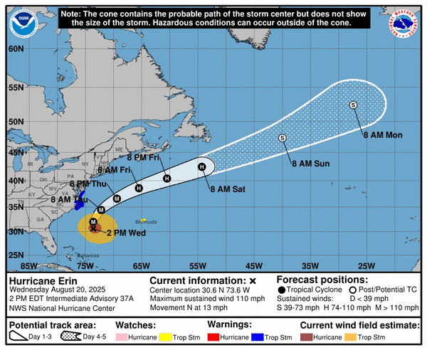
As of 2 p.m. Wednesday, Hurricane Erin was about 335 miles south-southeast of Cape Hatteras, North Carolina. Its maximum sustained winds had strengthened back up to 110 mph — making it a strong Category 2 hurricane. It was traveling north at 13 mph.
There is little doubt in Erin’s forecast track, which will turn north and then northeast, following the curve of the U.S. coast, then back out into the open Atlantic.
Erin is a large hurricane. Hurricane-force winds extend outward up to 105 miles from the center and tropical-storm-force winds extend outward up to 265 miles.
“Swells generated by Erin will affect the Bahamas, Bermuda, the east coast of the United States, and Atlantic Canada during the next several days,” the hurricane center said. “These rough ocean conditions will likely cause life-threatening surf and rip currents.”
The NHC issued tropical storm warnings from Beaufort Inlet, North Carolina, to Chincoteague, Virginia, including Pamlico and Albemarle sounds.
The Outer Banks should see tropical storm conditions beginning Wednesday night, along with the possibility of heavy rain Wednesday into Thursday, with the potential for 1 to 2 inches and a local maximum of 4 inches.
Storm surge, if it occurs at high tide, could be 2 to 4 feet above normal levels from Cape Lookout to Duck, North Carolina, the hurricane center said.
“The combination of a dangerous storm surge and the tide will cause normally dry areas near the coast to be flooded by rising waters moving inland from the shoreline,” the 8 p.m. forecast said.
Elsewhere, forecasters also are monitoring the system over the central tropical Atlantic that is currently a disorganized cluster of thunderstorms.
It could organize into a tropical depression or tropical storm by week’s end and reach the vicinity of the easternmost Caribbean Islands by Friday. As of 2 p.m. Wednesday, it has a 60% chance of developing in the next seven days, and a 10% chance of developing in the next 48 hours.
Forecasters said it was too soon to predict possible tracks, but that it is a system to keep an eye on. Its potential track has shifted north compared to previous outlooks.
Another system that emerged off the coast of Africa on Monday night has a 40% chance of developing within the next two days, forecasters said. It will enter an unfavorable environment later in the week as it moves west, lessening chances for development.
The next named storm will be Fernand.
©2025 South Florida Sun Sentinel. Visit at sun-sentinel.com. Distributed by Tribune Content Agency, LLC.


Comments