Tropical Storm Imelda stays east and takes its rain and winds with it
Published in Weather News
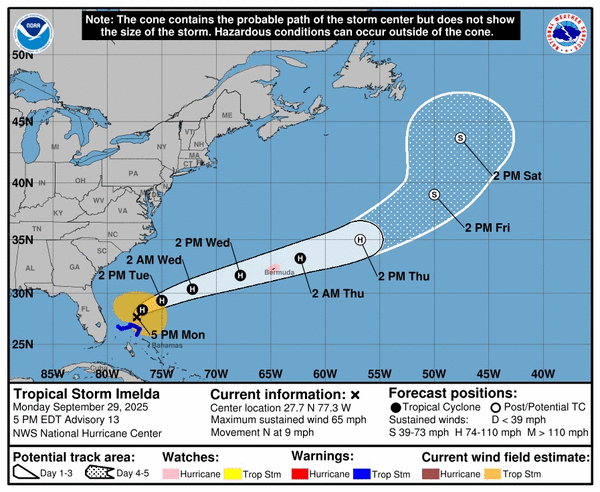
Tropical Storm Imelda began to pull away from Florida on Monday afternoon, taking its blustery winds and heavy rains with it.
Imelda’s drenching rains also began to ebb in the Bahamas on Monday, as most of the remaining tropical storm warnings were lifted Monday evening, minus the most northwestern islands of Grand Bahama and Great Abaco Island. Although some streets saw waist-deep flooding from Imelda’s rains, the Bahamian Tribune reported Monday that government services and businesses had already begun to reopen in the southern islands by Monday afternoon.
As Imelda moved even further offshore from Florida’s east coast, the threat of gusty winds and heavy rain dwindled.
However, the Miami office of the National Weather Service warned, Imelda will leave rough surf and riptides in its wake, making Atlantic waters more dangerous for days.
“Please, don’t go in the water if it doesn’t appear safe and heed any warning flags that are flying,” Michael Brennan, director of the hurricane center, said on a Monday morning video briefing about the storm.
As Imelda moves north, it’s expected to slowly strengthen and could reach Category 1 hurricane status as soon as Tuesday afternoon. But the storm’s slow forward speed and disorganization for much of its life means that it is getting drawn out to sea toward the far more powerful Hurricane Humberto.
On Tuesday, Imelda is predicted to make a hard right out to sea — heading toward now Category 4 Humberto and Bermuda. It could reach Category 2 as it approaches Bermuda, which was under a hurricane watch as of the 5 p.m. update from the National Hurricane Center.
The Carolinas could still see some leftover heavy rain from the outskirts of Imelda overnight Monday, forecasters said.
_____
©2025 Miami Herald. Visit miamiherald.com. Distributed by Tribune Content Agency, LLC.


Comments