Newly formed Hurricane Imelda leaves Bahamas, Florida behind, to take aim at Bermuda
Published in Weather News
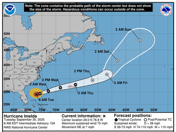
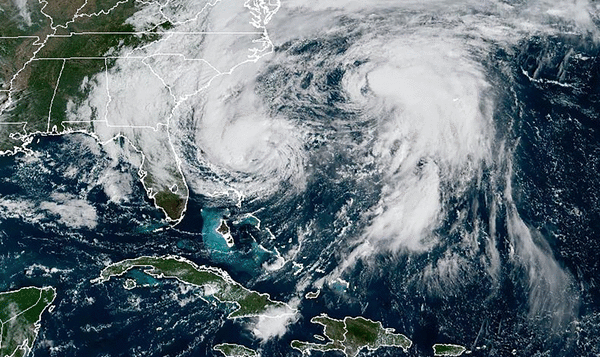

Hurricane Imelda formed Tuesday as it moved away from Florida and the Bahamas with a path that could make a direct hit on Bermuda, according to the National Hurricane Center.
As of the NHC’s 2 p.m. Eastern time advisory, the fourth hurricane of the season had maximum sustained winds that had grown to 85 mph, making it a Category 1 hurricane. It was located about 690 miles west-southwest of Bermuda moving east-northeast at 12 mph.
Hurricane-force winds extend out 45 miles and tropical-storm-force winds extend out 185 miles from its center.
“On the forecast track, the center of the hurricane should continue to move away from the Bahamas today and be approaching Bermuda Wednesday afternoon,” forecasters said. “Additional strengthening is forecast during the next 48 hours.”
A hurricane warning is now in place for Bermuda.
The storm slogged through the Bahamas on Monday and will continue to bring high surf and dangerous marine conditions to the Florida coast through the week, according to the National Weather Service in Melbourne.
“A high risk of rip currents, dangerous surf, moderate beach erosion, and hazardous boating conditions are forecast,” the NWS stated.
Surf heights will be 6 to 10 feet north of Cape Canaveral and 4 to 8 feet to the south.
Nearshore boating would be dangerous as well with 10-to-14-foot seas north of Cape Canaveral, 8 to 11 feet south and 11 to 18 feet offshore.
The NHC said 1 to 2 feet of surge could run from the Volusia/Flagler county line north to the South Santee River, South Carolina.
Outer bands from the system could bring 1 to 2 inches of rain with areas getting as much as 4 inches to the Carolina coast before the storm moves away from the U.S. mainland entirely.
Bermuda can expect 2 to 4 inches beginning Wednesday into Thursday.
Farther out in the Atlantic, the season’s third hurricane, which had reached Category 5 status Saturday with 160 mph winds, had lost its major hurricane status.
As of NHC’s 11 a.m. advisory Wednesday, Humberto had maximum sustained winds that had dropped to 80 mph, making it Category 1. It was located about 300 miles west of Bermuda moving north-northwest at 18 mph.
Hurricane-force winds extend out 70 miles and tropical-storm-force winds extend out 205 miles.
“On the forecast track, the center of Humberto will pass west of, and then north of Bermuda today and Wednesday,” forecasters said. “Continued weakening is forecast and Humberto is expected to become a strong extratropical system on Wednesday.”
So far the 2025 season has had nine named cyclones, all of which have grown to tropical-storm strength. Four have now become hurricanes, with all but Imelda having grown into major hurricanes.
The National Oceanic and Atmospheric Administration in early August updated its season forecast to call for 13 to 18 named storms, of which five to nine would grow into hurricanes. Two to five of those would develop into major hurricanes of Category 3 or higher.
Hurricane season runs from June 1 to Nov. 30.
---------------
©2025 Orlando Sentinel. Visit at orlandosentinel.com. Distributed by Tribune Content Agency, LLC.


Comments